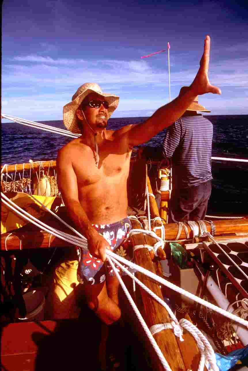
Navigator Bruce Blankenfield aboard Hokule'a using his hand to measure altitude of sun
Sam Low Photo
Star Navigation
Soundings Magazine
By Sam Low
The modern instrument navigator inhabits a world of abstractions. To find his place in the world, he reduces a star's altitude to a number, then consults his astronomical tables, does some math, and plots his position on a chart. He then forgets his navigational tasks until it's time for another peek through his sextant.
But the noninstrument navigator never ceases to regard nature. The world all around offers a continual heads up display' of stars, swells, and wind. Hokule'a's navigator, Nainoa Thompson constantly senses the direction of his vessel - in the soles of his feet, in the feel of wind on his cheek, in the sound of the rushing wake. He is continually, as he describes it, in the navigation.
Navigation is about understanding and watching nature, Nainoa once told me, everything you need to guide you is in the ocean, but you need to be skilled enough to see it. It took many years to learn the ocean's many faces, to sense subtle cues - the slight differences in ocean swells, in the colors of the ocean, the shapes of the clouds and in the winds.
Imagine an ocean of islands spanning ten million square miles. Now imagine you must navigate that world without charts or instruments - without even a compass - to find a tiny island 2500 miles away. If you fail, you will die. Impossible you say? Not at all. Such voyages were accomplished time and again a thousand years ago by ancient Polynesian seafarers. How they accomplished this feat has been a puzzle since Cook first revealed their watery domain in the late 1700s.
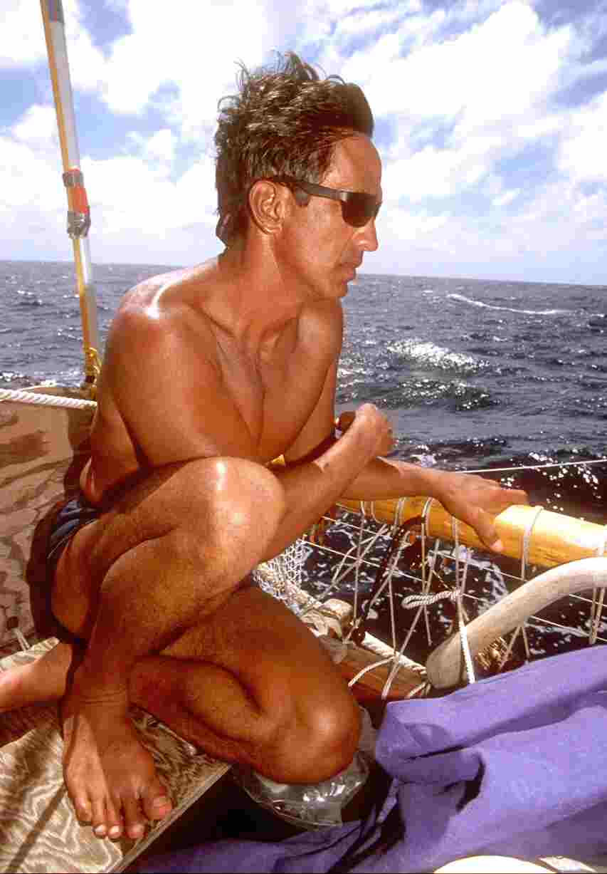
In 1974, Nainoa Thompson, began his quest to understand his ancestors' ancient navigational art by apprenticing to Mau Piailug, one of a handful of traditional navigators from Micronesia . He also spent hundreds of hours studying the sky in nature and in a planetarium at Hawaii 's Bishop Museum . Then he navigated Hokule'a a replica of a Polynesian double hull voyaging canoe on voyages spanning a quarter century and 100,000 nautical miles. His technique of navigation combines the traditional art of Mau Piailug with a more scientific and western' view of nature. We will never know how the Polynesians actually found their way but Nainoa's quest provides some clues..
Star Compass
By night, Nainoa steers by a compass defined by twinkling diamonds in the sky. The earth's axis of rotation points almost directly at Polaris the star that never moves a beacon of true north used by mariners for centuries. As earth spins, the other stars appear to rise in the eastern sky, arc overhead, and set in the west. Where they rise and where they set define points, or houses, on Nainoa's compass. Regulus, for example, rises at 78 degrees true and sets at 282 degrees true, Gacrux (the top star in the Southern Cross), rises at 147 degrees and sets at 213 degrees. In order to steer his canoe with confidence, Nainoa has memorized the rising and setting points of about 200 stars. He knows the sky so well that a glimpse of only a few twinkling points of light allows him to find his way on cloudy nights.
Pointer Stars
 In
the celestial firmament, Nainoa also discovered pairs of stars that cross he
meridian together pointers he calls them because they always point to either
the north or south celestial poles as they arc across the night sky. On the
equator, for example, a line drawn between the top and bottom stars in the Southern
Cross - Gacrux and Acrux - always point south. So does a line between Mirzam
and Canopus in the constellations
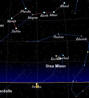
Canis Major and Carina. In the northern sky, Merak and Dubhe in the cup of the
Big Dipper point north, as do Edasich (in the Dragon) and Pherkad (in the Little
Dipper.) Corrections must be made as Nainoa sails away from the equator because
we live on a round earth and our view of the sky is tangent to it causing
the stars' rising and setting points of stars to vary with latitude. .
In
the celestial firmament, Nainoa also discovered pairs of stars that cross he
meridian together pointers he calls them because they always point to either
the north or south celestial poles as they arc across the night sky. On the
equator, for example, a line drawn between the top and bottom stars in the Southern
Cross - Gacrux and Acrux - always point south. So does a line between Mirzam
and Canopus in the constellations
Canis Major and Carina. In the northern sky, Merak and Dubhe in the cup of the
Big Dipper point north, as do Edasich (in the Dragon) and Pherkad (in the Little
Dipper.) Corrections must be made as Nainoa sails away from the equator because
we live on a round earth and our view of the sky is tangent to it causing
the stars' rising and setting points of stars to vary with latitude. .
Swells
During the day, Nainoa steers Hokule'a by the sun and ocean swells. In the Pacific, northeast and southeast trade winds set in motion a steady beat of swells that are relatively easy to detect. Much less obvious are swells stirred by local storms which only a trained navigator can see. At dawn, with the stars still visible, Nainoa orients these swells to his star compass.
Latitude
At the equator, the visible horizon is parallel to the earth's axis and so Polaris appears to rest on the ocean's surface. At one degree north latitude, Polaris will conveniently rise a single degree above the horizon. What is true for Polaris is true for all the rest. Moving north, every northern star rises and every southern star sinks exactly one degree for each degree of latitude change. Move south and the northern stars sink while the southern stars rise. Unlike Polaris these stars move, however, so their altitude must be measured when they cross the meridian the highest point in their arc. When observed from the equator, Acrux crosses the meridian at 27 degrees. Move north one degree and Acrux's highest rising is 26 degrees. So if you know the meridian altitude of any star at the equator simple math allows you to find your latitude anywhere on earth. Each star tells a different story, so Nainoa has memorized the paths of hundreds.
Nainoa uses his hand as an instrument to find a star's altitude. He orients his outstretched thumb to rest on the horizon, then reads altitude against landmarks in his flesh. If a star rises to the height of his second knuckle, for example, he knows its altitude is 15 degrees.
Simultaneous setting
While studying the stars in Hawaii , Nainoa observed Mirzam set below the western horizon, followed by Sirius, Castor and Pollux. But when he traveled to Tahiti , he watched Mirzam and Castor set at the same time, followed by Sirius and Pollux which also set simultaneously. A little research showed that at only 18 degrees south latitude will Mirzam and Castor and Sirius and Pollux set together. A new navigational concept was born simultaneous setting another key to latitude. Diligent research revealed many other such star pairs.
Equal Distance - Meridian Pairs
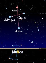 Watching
the Southern Cross arc to its meridian at the latitude of Hawaii
, Nainoa noticed that the distance between the top star
(Gacrux) and the bottom star (Acrux) was exactly equal to the distance between
Acrux and the horizon. Thinking about this a little more, he realized that whenever
an observer sees this equal spacing he will be at 21 degrees north.
Watching
the Southern Cross arc to its meridian at the latitude of Hawaii
, Nainoa noticed that the distance between the top star
(Gacrux) and the bottom star (Acrux) was exactly equal to the distance between
Acrux and the horizon. Thinking about this a little more, he realized that whenever
an observer sees this equal spacing he will be at 21 degrees north.
What is true for Gacrux and Acrux is true for all the other pointer stars. At 5 degrees south latitude, for example, the distance between Pherkad (in the Little Dipper) and Edasich (in Draco) is the same as the distance between Pherkad and the horizon. Applying this principle to the all the pointer stars, Nainoa had discovered a sure way to find his latitude at many different points on the globe.
Longitude
Instrument navigators find their longitude by comparing their local time with the time at Greenwich , England . Without a chronometer and sextant, Nainoa finds his longitude as navigators did for millennia by dead reckoning.
 On
many voyages I have watched him as he seems to enter a zone of intense concentration
observing the sea and sky for clues to the course steered and the distance
made good. He plots these calculations on a mental map, adjusting his estimated
position at sunrise and sunset. So intense is this mental process that he sleeps
only a few hours each day in a series of thirty minute catnaps.
On
many voyages I have watched him as he seems to enter a zone of intense concentration
observing the sea and sky for clues to the course steered and the distance
made good. He plots these calculations on a mental map, adjusting his estimated
position at sunrise and sunset. So intense is this mental process that he sleeps
only a few hours each day in a series of thirty minute catnaps.
His dead reckoning' technique of plotting his position mentally involves western concepts of trigonometry resolved into proportions he has memorized and applies daily. He figures his course made good and calculates this position utilizing a reference course' previously plotted on a chart which he memorized (he uses no charts when actually navigating).
Island Screens
On many voyages, Nainoa aims for a screen of islands such as the Society Island-Tuamotu-Marquesan chain that lies across hundreds of miles of ocean. He then uses signs of land to determine the proximity to landfall birds, flotsam, the presence and coloration of clouds. These must have been techniques known to ancient Polynesian navigators as well.
The acid test
On one voyage that to Rapa Nui his system was tested to the fullest as he aimed Hokule'a to a tiny speck of land alone in an immense sea. A mistake of only one degree in estimating the altitude of a star at its meridian would translate into an error of 60 miles at sea. Rapa Nui is observable from a distance of only 30 miles so Nainoa's navigation had to be spot on to find the island. Yet he did after 17 days at sea proof of the concept that a trained noninstrument navigator can be deadly accurate.
A hybrid System
Nainoa's is a hybrid system, our Polynesian ancestors did not divide their world into lines of longitude and latitude, for example, nor did they have charts. Nevertheless, many of the observations he used to find his way must have been available to ancient Polynesians as well. The star compass, which still is used in Micronesia, is one such technique as is Mau's reliance on wind and wave for direction and his use of birds, flotsam and sky coloration. What ties Nainoa's system to the ancient one is a similar painstaking observation of the natural world seeking clues to location in the night sky and the world around him. Polynesian navigators undoubtedly noticed the shape of the sky changing as they moved across Earth - the rising and setting points of stars, their arc across the sky, the height they rose to, perhaps even relationships such as equal distances and simultaneous setting. How they used these observations we will never know with certainty.
The lesson
The voyages of Hokule'a and of other recreated Polynesian canoes have proven the concept that such vessels could have carried colonists across thousands of ocean miles and that you do not need instruments to find your way across trackless space.
The lesson for those of us confined today within four walls and the concepts of math and science, is an appreciation for another way of seeing the world. While we may never know if Nainoa's way was used by our ancestors, we can marvel at what can be achieved if one just systematically observes the world all around us. It is this technique of patient observation that must have been similar across time and geography allowing the Polynesians to settle ten million square miles of Earth's surface.
And finally, like all who settle into a sure confidence in their abilities, Nainoa was able to achieve a state of oneness with the world around him that allowed him to become an artist trusting in his trained instinct.
When everything is going right, Nainoa once explained to me. I get into a zone, a special place in which all of my relations with the canoe, the natural world and the crew are integrated. You have to be in that special place to navigate well. When you are in the zone, you feel ahead of the game. You find yourself naturally thinking about what will happen next and you are acting in the future, not reacting to things in the past. You have the star patterns in mind and you seem to know where you are even when the sky is cloudy and you can't see the stars. You begin to anticipate the weather. It's an awesome feeling but it's hard to describe. It is like being inside the navigation, participating from the inside.