|
A
World of Natural Signs
By
Sam Low
Sailing Magazine
"Bring
her down!"
With this command from the navigator, my watchmates and I throw our
weight against the steering paddle to bring our vessel off the wind.
For days, we've been sailing through heavy swells frosted with whitecaps.
A chilled 25-knot wind blows over our bow. Rain slants across the decks.
We are aboard a sailing craft the likes of which have not been seen
for centuries. She is called Hokule'a - star of gladness - and she is
a replica of canoes that once carried Polynesian explorers to discover
and settle thousands of islands in a vast watery domain known as the
Polynesian Triangle. Since she was launched in 1975, Hokule'a has sailed
to all the corners of the triangle - except to the east which is anchored
by the tiny island of Rapa Nui (Europeans call it Easter Island) - our
destination.
To a modern sailor's eye, Hokule'a appears strange. She is sixty-two
feet long. Her twin hulls are joined by laminated wooden iako and fastened
by rope lashings woven into complex patterns reminiscent of the art
of M. C. Escher. The deck is lashed over the iakos to provide a place
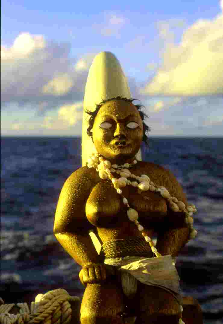
for the crew to live during the day. The hulls rise up sharply at each
end and terminate in a graceful arc, called a manu, where wooden figures
with high foreheads and protruding eyes, the akua or guardian spirits,
stare out over an empty sea. Viewed from above, the canoe's strangeness
is dispelled. She looks like a catamaran.
Hokule'a's shape is ancient but her construction is not. A hundred years
ago, her sails would have been woven from Pandanus frond, but no one
knows how to do that today so they are made of Dacron. Her hulls are
fiberglassed marine plywood because the art of carving such canoes from
live wood has almost vanished along with the ancient canoe makers, the
kahuna kalai wa'a. Nainoa Thompson, the canoe's navigator, calls her
a "performance replica."
"We wanted to test the theory that such canoes could have carried Polynesian
navigators on long voyages of exploration throughout the Polynesian
triangle. We wanted to see how she sailed into the wind, off the wind,
how much cargo she could carry, how she stood up to storms. Could we
navigate her without instruments? Could we endure the rigors of long
voyages ourselves? Frankly, that was enough of a challenge. It didn't
matter if the canoe was made of modern materials as long as she performed
like an ancient vessel."
The Polynesian triangle is a huge chunk of real estate, larger than
all of Europe. Before her first voyage in 1975, academics and seafarers
were pretty much mystified by how the Polynesians settled such a vast
ocean. Thor Heyerdahl had a vision of sailors riding the prevailing
winds and currents from South America aboard balsa rafts - drifters,
not sophisticated seafarers. In 1948, he sailed Kon Tiki from Peru to
the Tuamotu Islands to settle the point. But he was wrong. Evidence
from archeological excavations, genetic research, linguistics and anthropology
has since proven that Polynesia was colonized from Southeast Asia by
sailors who voyaged against the wind and currents, explorers embarked
in craft much like Hokule'a.
It is September 29, the 8th day of our voyage. For the last week we
have lived in our heavy weather gear--working, eating and sleeping fully
tented in glossy yellow Patagonia slickers.
"This voyage will test you," Nainoa told us a few days before departing,
"it will test you physically, mentally and spiritually."
After our watch, we seek shelter in our "pukas" - a space about 6 feet
long and 3 feet wide under a sloping canvas roof which is only partially
watertight - it bleeds brackish droplets, a mixture of salt spray and
rainwater. Still carapaced in our foul weather gear, we slither into
our berths and try to sleep, grateful for the respite from the cold
wind and the cry of "bring her down!"
But one of us almost never goes below. Nainoa spends his time on deck
in all weather, mostly awake, always alert to the wind, stars and swells.
He catnaps in bad weather like this, a sprawled lump of yellow pants
and slicker, his hood pulled tight over his head, for maybe 15 minutes
at a time. The rest of us sleep at least 6 hours a day and often more,
yet we still are fatigued.
From our jumping off point in Mangareva we plan to sail east more than
1500 miles into the open Pacific. We will navigate as the ancients did
- without charts or instruments, we will use the stars, ocean swells
and flight of birds to guide the canoe. Our target is tiny, Rapa Nui
is only about 14 miles wide and 20 long. An error of only ½ a degree
in estimating latitude (an equivalent of 30 nautical miles) will cause
us to sail past the island. The next stop will be South America, 2000
miles away.
"The voyage to Rapa Nui will be the ultimate proof that our ancestors
were able to navigate successfully anywhere in their world," Nainoa
told us before we departed.
During the voyage Nainoa spends most of his time on the navigator's
platform aft, staring out to sea. I am careful not to interrupt his
concentration, waiting until his vision has refocused on something aboard
the canoe before talking to him (my job is to document the voyage in
words and photographs). I begin to see Nainoa willing himself back a
few thousand years to an era when Polynesian navigators sailed across
this same expanse of ocean.
"When everything is going right," Nainoa once explained to me. "I get
into a zone, a special place in which all of my relations with the canoe,
the natural world and the crew are integrated. You have to be in that
special place to navigate well. When you are in the zone, you feel ahead
of the game. You find yourself naturally thinking about what will happen
next and you are acting in the future, not reacting to things in the
past. You have the star patterns in mind and you seem to know where
you are even when the sky is cloudy and you can't see the stars. You
begin to anticipate the weather. It's an awesome feeling but it's hard
to describe. It is like being inside the navigation, participating from
the inside."
Nainoa's system of navigation is like all great discoveries - both complex
enough to render description difficult yet, at its foundation, incredibly
simple. It is based on years of observation, both of the real sky and
of an artificial one - in the planetarium of Hawaii's Bishop Museum.
It is also based on the teachings of Mau Piailug, one of the last Micronesian
Palu, navigators who find their way by a world of natural signs.
As a compass Nainoa uses the rising and setting points of stars. On
this voyage, for example, Sirius rises at 107 degrees and Aldebaran
rises at 70 degrees; while Vega sets at 317 degrees and Antares at 242
degrees. In the entire menu of Nainoa's directional stars there are
about 200. Swells also provide clues to steer by. Take the southwest
swell (Correct?) that has accompanied us for the entire voyage. Generated
by a hurricane off the coast of Australia, more than 5000 miles away,
it is satisfyingly deep and constant. We set our course by it at during
the day and at night when the sky is occluded, which is often.
The big trick, of course, is not just knowing where we're going but
where we are at any given moment. Determining Latitude, our position
north and south, is accomplished by judging the altitude of stars above
the horizon when they are at the meridian - the highest point in their
arc across the sky. Each star tells a different story because it arcs
differently, so the navigator has to memorize the path of dozens of
them. Judging altitude takes practice and the ability to use one's hand
as a crude instrument. Nainoa's little finger, when held at arms length
and adjusted to lie along the horizon, marks off 2 degrees of altitude.
Sighting along the crease between his hand and upthrust thumb gives
a reading of 13 degrees.
During Nainoa's study in the planetarium, he traveled across the ocean
in compressed time to observe patterns in the wheeling night sky. He
noticed certain pairs of stars rising and setting on the horizon simultaneously
- but only at one specific latitude - a phenomenon he calls "synchronous
rising and synchronous setting." When Murzim (near Sirius) and Alhena
(in Gemini), for example, drop below the western horizon at the same
time he knows the canoe is at six degrees south latitude. When Sirius
and Pollux set together he knows that his position is 17 degrees south.
Every day at sunrise and sunset, Nainoa gathers with two assistant navigators,
Chad Baybayan and Bruce Bruce Blankenfeld, to assess their progress
in the previous twelve hours. On the morning of October 1st at dawn,
the three men look out over an ocean stirred only by gentle undulating
swells and ruffled by tiny wind ripples.
"What an awesome night that was," says Nainoa, "I saw Jupiter rise on
the horizon, so the atmosphere was really clear. I was able to get a
good view of Atria in the south and Ruchbah in the north. The latitude
I got from Atria was 25 degrees S, and from Ruchbah I got 26 degrees
S. I think we ought to average the observations so let's say we are
at 25 degrees 30 minutes S."
Longitude cannot be found without a chronometer, so the navigators rely
on a system called, appropriately enough, "dead reckoning." They estimate
the time and speed they steer a given course and, on a mental map, they
place themselves along an imaginary course line toward their destination.
Last night, on the 6 to 10 p.m. watch, Hokule'a was beset with light
fickle winds.
"I don't think we made any progress during that watch," Nainoa says.
The canoe was stalled during the other watches as well. When the three
men add up their estimates of miles traveled during the night - factoring
in the effects of steering various courses as the fickle winds permitted
and leeway - they arrive at an estimate of only 6 miles of easting.
But this progress was impeded by a westerly current so the net distance
traveled east was only 3 miles. According to their calculations, the
distance to Rapa Nui is now 461 miles. In all of these calculations,
errors naturally accumulate.
"We can guess our distance traveled by dead reckoning, if we are very
careful, with maybe a 10% error, and we can guess our latitude with
an error of about one degree," Nainoa says.
I do the math in my head - 10% of 1500 miles (the distance along our
east- west course line toward Rapa Nui) is 150 miles. One degree of
latitude (along a north south line) is 60 miles. So that gives us a
box of accumulated error that is equivalent to nine thousand square
miles. Finding the tiny island in that vast space seems at best improbable
- but that's a personal opinion, which I keep to myself.
"One thing has always been certain," Nainoa says, "if we looked at this
voyage scientifically there is almost no chance of finding Rapa Nui.
If we thought that way, we would not have chosen to go. But you know
what? I bet we find it!"
During the evening of October 2nd, the sky presents millions of stars.
The wind is gentle, northerly. Jupiter rises ahead, almost due east.
I steer by aligning skymarks with various parts of the canoe - Jupiter
with the forestay, the Scorpion with the upthrust sternpost, Alpha Centauri
with a starboard shroud. As Jupiter rises from the sea it arcs north.
The angle its arc makes to the horizon matches both our latitude and
the tilt of Earth's axis, about 26 degrees. When Jupiter rises as high
as Hokule'a's mast it no longer serves as a trusty guide, but then Saturn
breaks the horizon and I line it up with one of the canoe's fore shrouds.
The ancient Hawaiians called the planets hoku 'ae'a - wandering stars
- because they appear to move through the otherwise permanent starfield.
Our ancestors probably employed the planets as we do, by using the stars
to determine their positions before we set our course by them.
During the next four days the winds are fickle, on and off from differing
directions. The sky clouds over. During the evening of October 6th and
the early morning of the 7th we continue toward Rapa Nui, tacking occasionally
to take advantage of wind shifts, hoping the sky may provide a glimpse
of our guiding stars. This does not happen. With only the swells to
provide direction, our navigators guide us to our rendezvous with an
invisible abstraction - the latitude of Rapa Nui - 27 degrees 9 minutes
S.
At 6 a.m. on October 7th, Bruce, Chad and Nainoa predict that we are
28 miles north of the latitude of Rapa Nui and 217 miles west of the
island. But we have sailed a zigzag course for the last few days, which
makes dead reckoning difficult. Under the best of conditions, error
accumulates - and, for the last few days the conditions have been far
from the best.
All that night and on into the morning the winds continue to blow strong
from the northeast and Hokule'a responds by speeding east-southeast
- 6 to 7 knots at times - slicing through the waves, producing long
tendrils of spray from her bow. Lookouts are posted. Near dawn, Max
Yarawamai spots two holes in the clouds ahead low on the horizon.
"I looked carefully at the two holes," Max explained later, "checking
first the one on the starboard side. I saw nothing there so I switched
to the hole on the port. I saw a hard flat surface there and I watched
it carefully. Was it an island? The shape didn't change! It was an island
all right." Nainoa's latitude estimation was dead on, and his dead reckoning
of longitude was accurate to within perhaps fifty miles. We had found
the dot in the ocean.
During that day we sail toward the island. Night descends. The lights
of Hanga Roa glisten on the eastern horizon. We ghost along the coast
of Rapa Nui until the watch change at ten PM when we tack toward the
island - a dark smudge on the horizon against a glittering curtain of
stars.
The 6-10 watch lingers on deck, enjoying the last few moments of comradeship
with each other and with our canoe. We watch Jupiter and Saturn rise
over the island to starboard and to port the Pleades and their guardian,
Taurus. We do not speak - our presence together on Hokule'a's heaving
deck expresses more deeply then words the bond that has been made in
the last seventeen days at sea.
Reflecting back on the trip, I remember a serene and crystalline night
when Hokule'a slipped gracefully over gentle swells. The canoe's deck,
open to the skies, made it seem like I could reach up and touch the
Milky Way. Plankton glowed in our wake, turning the sea as effervescent
as champagne. Large globs of green light flared up, shimmered for an
instant, then slowly faded. We seemed to float through a universe of
jewels. I watched the helmsman bend over the canoe's massive steering
paddle. In silhouette against the sky he appeared engrossed in the performance
of an ancient ritual. Here, perhaps as far away from the influence of
modern life as one can get, time stood still. I imagined myself on the
deck of an ancient Polynesian canoe, making the first voyage to Rapa
Nui. The past lived.
|